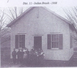
This week we return once again to the western section of the Township of Greene for another chapter of school history and the one-room schools which were so important to the education of the children of another year and another time. The Indian Brook School began life in the year 1830 and would be active till after centralization came in and finally was the death of yet another educational building in 1945. The photo (s) of the school which were taken in 1908 and 1962 respectively give us the prized look of how the school looked when in operation and the other of how it looked when it was converted to a private dwelling. Mrs. Folsom’s book “Town of Greene - Rural School Districts” p. 42 relates the extensive research that she conducted regarding all the district schools of the Greene Township.
Commissioners and Inspectors of this district school during its lifespan were many and to pay homage to a few the names of Williams, Willard, Patterson, Sharp, Bouton, Gilbert, Purple, Crombie, Spafford, Wheeler, Bartoo, are but a spattering of the gentlemen who gave their timeto make positive that their children and everyone’s children living in the above named district received the best education that was available during the years the school was active.
The location of the Indian Brook School bringing the site into the current century is located atapproximately the corners of Indian Brook Road and Vosburg Road, and according to Mrs. Folsom’s book was still standing when she wrote the above school histories.
Commissioners and Inspectors throughout the course of this district’s existence were many and varied. To list all their names would be extensive but to name a few the following names appear in the research of Mrs. Folsom’s book. Williams, Willard, Patterson, Bouton, Hoyt, Squire, Purple, Crombie, Chase Dunn, Wheeler, are but a few who names appear in the books of research that Mrs. Folsom conducted.
The boundary lines of the property of this district school, and we will assume this fact, that the property was owned on all four sides of the school by Henry C. Hays. As has been repeated in previous articles the boundary lines were changed many times as will be noted in the following sentences. 1832 - West half of 70/TM occupied by Harmon Terwilliger from #11 to #6, 1835 - farm of Thomas Alexander from #11 to #23, 1838 - west half of 60/3T from #2 to #11 (Smithville), 1838 yet another change - Farms of Heath Davis, Charles Williams, Luman Benedict (the whole of 60/3T in Town of Greene to #11 (Smithville). 1843 - Farm of Lyman church from #2 to #11 (Greene and Smithville), 1847 - New district #7 formed: All of #11 (Greene and Broome) on east side of river, parts of lots 19-20-22. Lots 15, 16, 17-18/ Jay’s Patent from #7 to #11,1851 - East part offtll (Greene, Chenango, Barker) to be called Dist. #2. West part to be #1l in Chenango and Barker, 1852 - Farm of Lyman Church from #11 (Greene & Oxford) to #2 in Greene and finally the last change in district lines was 1874 - Part of lot #60 occupied by D. H. Towslee in #11 (Greene and Smithville) to #22. Additionally in 1902 the school District #10 (Smithville) burned October 26th, 1902, the district was dissolved and annexed to the following districts #6, 8, 23 of Smithville and #22 of Greene. This writer will state at this time to fully understand these district line changes, maps would have to be studied with the property owner’s names and updated from there, possibly by laying the new lines upon the old ones. Ah, an extensive research project to say the least.