Approaching rather rapidly is the holiday season for 2010 and originally the thought would be to discontinue the series for the season and resume after the January 1, 2011. How time does fly when is seems only yesterday that we were approaching the twenty-first century and the concern was would the computer systems throughout the world accept the change from reading 1999 to the year 200, more commonly known as Y2K. Well all is well that ends well!
As this article is #97 in this ongoing series and if all goes as planned, the first article for the New Year will be #100, wish me luck! There were 315 districts in Chenango County when the educational system was put in effect, so as the saying goes “stay tuned.”
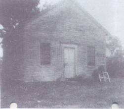
The district so named above is described in the boundary lines researched by Mildred Folsom in her book “Town of Greene - Rural School Districts” p.4 as being bordered by the properties of Reuben Peck, Zachariah Bradley, David Winchell, Samuel Carpenter and David Bradley. This early district came into existence in 1828 and was finally closed in 1935, nearly a century of service for education. Quite a remarkable part of the Town of Greene’s history!
Again the boundary lines of this district would see the following changes, 1837 - farm of Samuel Carpenter from #10 to #9, again in 1845 - Samuel Carpenter’s farm from #9 back to #10, and finally in 1880 District #10 was divided in 2 districts. The taxable inhabitants of #10 being Samuel Rooney - Hubbard Sharp - Ichabod Sharp - Eugene Monk - Floyd Whitmarsh - James Clark - S. E. Barnett - Samuel Lee - F. F. Peck - G. D. Mitchell - Thomas Baldwin - Fred S. Cohoon - F. F. Peck (2nd parcel) - G. D. Mitchell - Thomas Baldwin - Fred S. Cohoon and Frank Morehead. This early district was located on what is now known as the Echo Lake Road according to this writer’s interpretation of the 1875 Atlas map of Chenango County and the latest Chenango County map with the naming of all roads.
The deed recorded for this school property according to Mrs. Folsom’s research from the above source p. 11 reads: Book 109 - p. 416 dated 1860 - Willis and Livonia Forbes to Luther Whitmarsh -Trustee of District #10 for a schoolhouse (was this the second building?) - land beginning in center of highway running from Genegantslet Corners to Smithville Flats at northeast corner of lands owned by Stephen W. Davis (the farm previously owned by Eli Webb - deceased) - north to another road intersecting the one mentioned – along it southeast 14 rods to north line of Eli Webb farm (being now a part of said which is owned by Willis Forbes- west to point of beginning: $15/100 acres. $5.00. Yet another deed was filed in Book #288, p. #446 in 1932 where August and Marie Radau to District #17 (formerly #10) for $50. Beginning at northeast corner of district, north 129’, west 75’, and south 211’, east 9’ to southwest corner of present schoolhouse, and north 5 rods. From this information did the school district sell to the Radau’s part of the land that the schoolhouse was located on? Ah, the mysteries of history!